Project: JejuWorld Natural Heritage Centre (competition entry, 2nd prize)
Project Team: poly.m.ur, (Homin Kim, Chris S. Yoo)
Design Team: Suk-hee Kwon, Yei-seul Oh, Eun-yu Lee, Kwang-ho Chung
Location: Jeju, Korea
Date: Aug. 2009
Area: 6,900 m²
프로젝트: 제주 세계자연 유산 센터
설계팀: poly.m.ur (김호민, 유승우, 권숙희, 오예슬, 이은유, 정광호)
위치: 제주시
일자: 2009
프로젝트 성격: 현상설계제출안 (2등)
건물면적: 6,900 m²
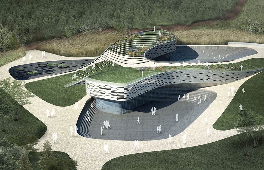
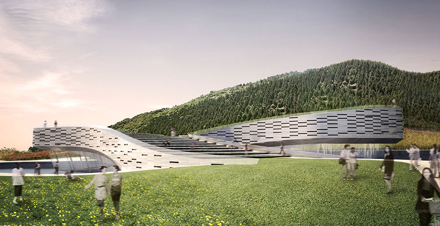
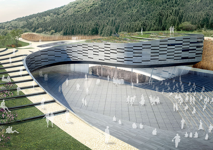
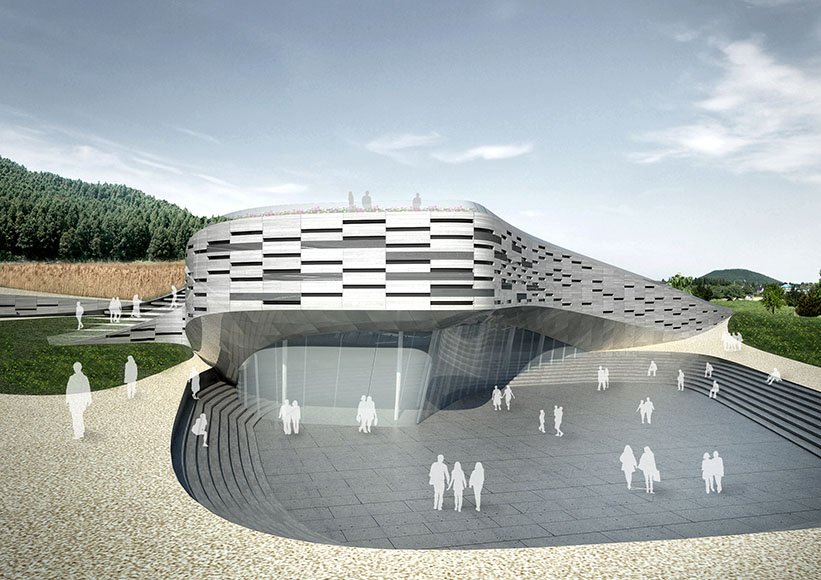
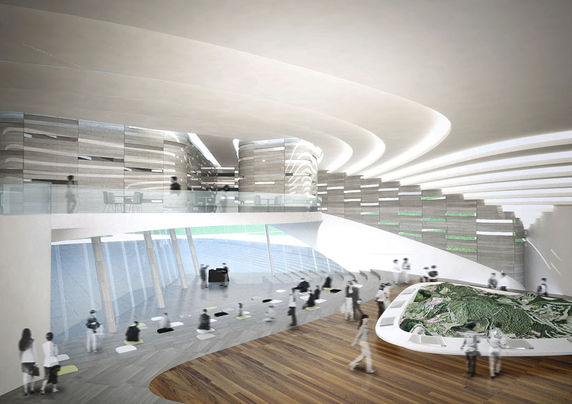
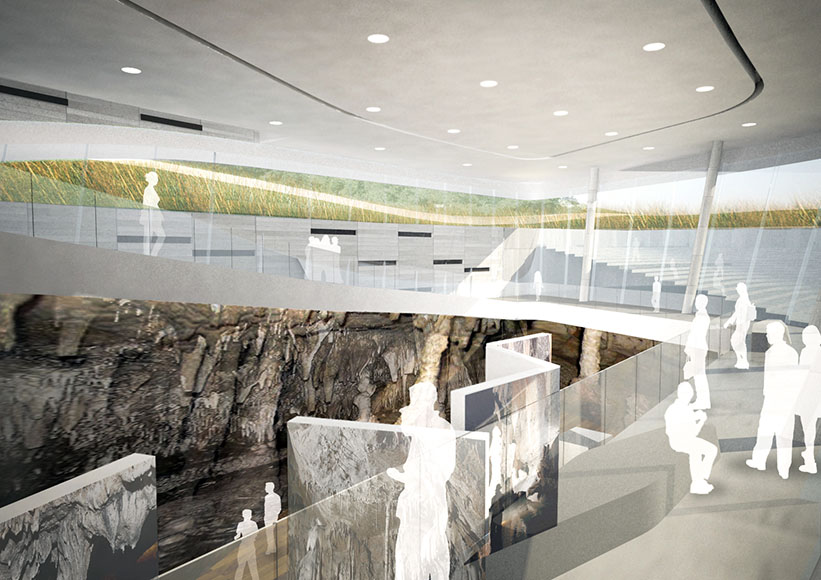
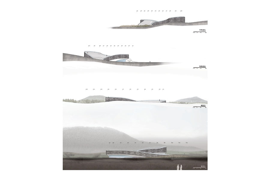
Jeju is an island formed by volcanic activities and celebration of its distinctive geological features was one of the main objectives of the brief. The design started from answering the brief which explicitly requested that the scheme to symbolise the volcanic landscape of Jeju consists of caves and mounds. We viewed these two geological feature in terms of their morphological formations - one as constructive space (volcanic mounds) and the other one as subtractive space (volcanic caves), and were represented in the formation of the massing of our scheme.
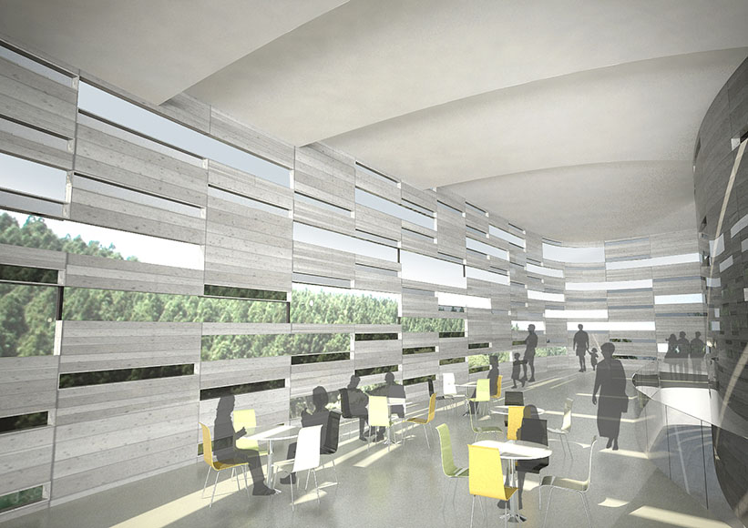
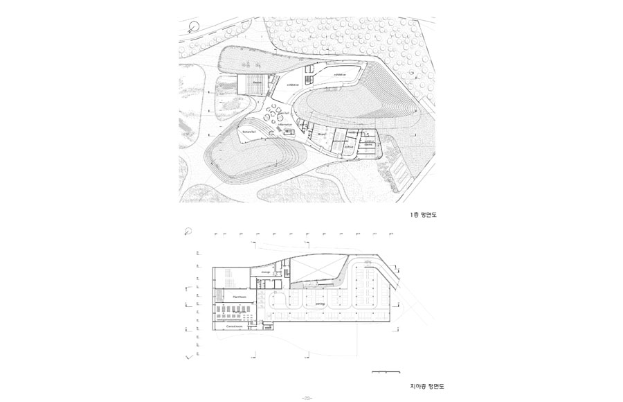
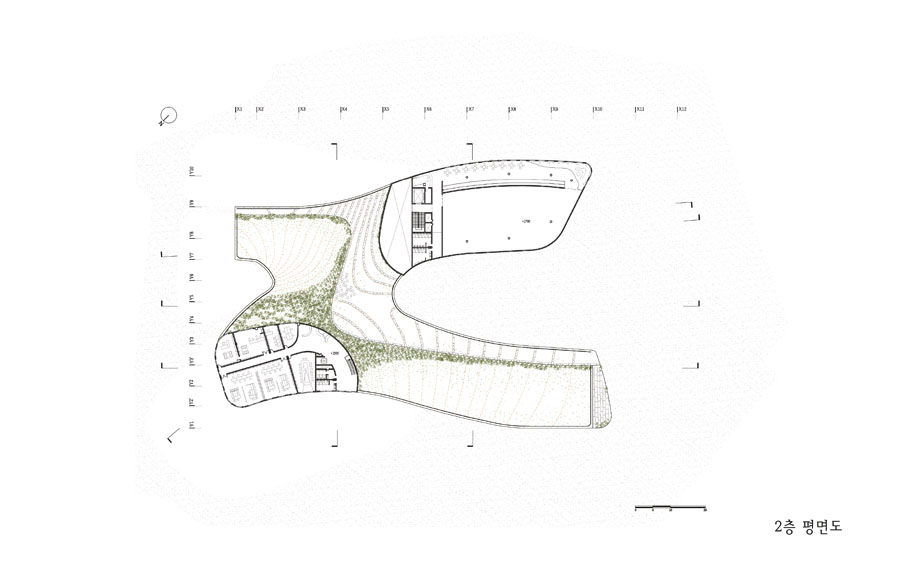
We also wanted the centre to be recognised as a ‘place’ rather than an ‘image’, a direct representation of volcanic forms, while its inspiration taken from the volcanic form is still recognisable. The roof of the scheme is formed by following the existing landscape and gently lifting up some areas of the site forming terraced pathways and viewing decks. Where the landform has been lifted, sunken terraces are formed to counter the action. The overall circulation strategy is central to the place making which forms a knot creating crossings and loops in, out and around the roofscape, sunken terraces and the interior spaces. The seamless flow of people in and out of the building was central to the design of the scheme. This system of pedestrian pathways is also expanded out of the site and creates links between sporadic access points to the tracks in the mounds and the village’s road network, so that the centre not only works as a educational and touristic facility for visitors but also works as a place for the locals.
제주의 오름과 동굴을 상징할 수 있어야 한다는 요구로부터 시작된 고민은 직접적인 형태를 통한 상징성에서 탈피해 제주지형 구축방식의 응용에 초점을 맞추어 진행하였다. 제주의 지형은 오름과 동굴의 두 가지 큰 화산활동으로 이루어졌다. 지형을 밀어올려 생성된 공간(constructive space)으로서의 오름과 그것을 파고 들어가며 만들어진 공간(subtractive space)으로서의 동굴이 지닌 방식을 프로그램과 매싱의 생성 과정에 응용하여 오름과 동굴을 은유적으로 표현하는 방법으로 이끌어냈다.
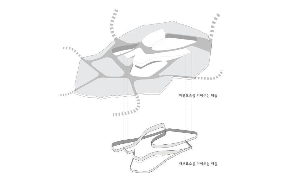
또한 유산센터가 단순한 ‘이미지’ 로서 상징물이 되기보다는, 지역민들과 기존 자연의 문화적인 중심공간의 역할을 담당함으로써 ‘장소’ 그 자체로서 랜드마크가 되도록 의도하였다. 유산센터의 지붕은 기존지형을 그대로 받아들여 구성하였고 내부와 외부로 들어가는 길들이 리본형태가 됨으로써 전체 대지와 유기적으로 엮이도록 하고 결국 전체 사이트를 가로지르고 구분하는 동선이 유산센터의 내부와 외부의 길들이 되어 건축은 독립된 오브제를 탈피해 거문오름동굴계를 위한 공간의 일부로서 작동하도록 계획하였다.
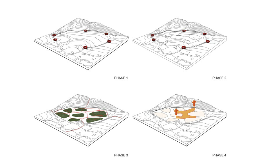
대지내 고리(LOOP)형 동선들을 배치해 거문오름 주위에 산재한 탐방로들을 엮고 이으며 유기적인 동선 체계를 구축하고 거문오름과 주변 마을의 생태를 연결하는 고리가 될 수 있도록 하였다. 또한 동선들이 서로 겹치고 마주치는 곳에 유산센터가 있어 탐방객들이 모이고 흩어지며 자연스럽게 내외부 전시를 감상할 수 있으며 방문객들뿐만 아니라 주민들도 활발하게 참여할 수 있도록 주변마을(선흘리)의 환형의 길체계를 적용함으로써 세계유산센터와 유기적으로 엮어지도록 계획하였다.
Project Team: poly.m.ur, (Homin Kim, Chris S. Yoo)
Design Team: Suk-hee Kwon, Yei-seul Oh, Eun-yu Lee, Kwang-ho Chung
Location: Jeju, Korea
Date: Aug. 2009
Area: 6,900 m²
프로젝트: 제주 세계자연 유산 센터
설계팀: poly.m.ur (김호민, 유승우, 권숙희, 오예슬, 이은유, 정광호)
위치: 제주시
일자: 2009
프로젝트 성격: 현상설계제출안 (2등)
건물면적: 6,900 m²
Description
Jeju is an island formed by volcanic activities and celebration of its distinctive geological features was one of the main objectives of the brief. The design started from answering the brief which explicitly requested that the scheme to symbolise the volcanic landscape of Jeju consists of caves and mounds. We viewed these two geological feature in terms of their morphological formations - one as constructive space (volcanic mounds) and the other one as subtractive space (volcanic caves), and were represented in the formation of the massing of our scheme.
We also wanted the centre to be recognised as a ‘place’ rather than an ‘image’, a direct representation of volcanic forms, while its inspiration taken from the volcanic form is still recognisable. The roof of the scheme is formed by following the existing landscape and gently lifting up some areas of the site forming terraced pathways and viewing decks. Where the landform has been lifted, sunken terraces are formed to counter the action. The overall circulation strategy is central to the place making which forms a knot creating crossings and loops in, out and around the roofscape, sunken terraces and the interior spaces. The seamless flow of people in and out of the building was central to the design of the scheme. This system of pedestrian pathways is also expanded out of the site and creates links between sporadic access points to the tracks in the mounds and the village’s road network, so that the centre not only works as a educational and touristic facility for visitors but also works as a place for the locals.
제주의 오름과 동굴을 상징할 수 있어야 한다는 요구로부터 시작된 고민은 직접적인 형태를 통한 상징성에서 탈피해 제주지형 구축방식의 응용에 초점을 맞추어 진행하였다. 제주의 지형은 오름과 동굴의 두 가지 큰 화산활동으로 이루어졌다. 지형을 밀어올려 생성된 공간(constructive space)으로서의 오름과 그것을 파고 들어가며 만들어진 공간(subtractive space)으로서의 동굴이 지닌 방식을 프로그램과 매싱의 생성 과정에 응용하여 오름과 동굴을 은유적으로 표현하는 방법으로 이끌어냈다.
또한 유산센터가 단순한 ‘이미지’ 로서 상징물이 되기보다는, 지역민들과 기존 자연의 문화적인 중심공간의 역할을 담당함으로써 ‘장소’ 그 자체로서 랜드마크가 되도록 의도하였다. 유산센터의 지붕은 기존지형을 그대로 받아들여 구성하였고 내부와 외부로 들어가는 길들이 리본형태가 됨으로써 전체 대지와 유기적으로 엮이도록 하고 결국 전체 사이트를 가로지르고 구분하는 동선이 유산센터의 내부와 외부의 길들이 되어 건축은 독립된 오브제를 탈피해 거문오름동굴계를 위한 공간의 일부로서 작동하도록 계획하였다.
대지내 고리(LOOP)형 동선들을 배치해 거문오름 주위에 산재한 탐방로들을 엮고 이으며 유기적인 동선 체계를 구축하고 거문오름과 주변 마을의 생태를 연결하는 고리가 될 수 있도록 하였다. 또한 동선들이 서로 겹치고 마주치는 곳에 유산센터가 있어 탐방객들이 모이고 흩어지며 자연스럽게 내외부 전시를 감상할 수 있으며 방문객들뿐만 아니라 주민들도 활발하게 참여할 수 있도록 주변마을(선흘리)의 환형의 길체계를 적용함으로써 세계유산센터와 유기적으로 엮어지도록 계획하였다.